Type | Spanish research project
Duration | 2015 - 2017
Project leader | Antoni Burguera Burguera
Collaborators | Yolanda González Cid | Dietrich Paulus | Jose Luís Lisani | Ana Belén Petro | Francisco Bonin-Font | Miquel Massot Campos
Duration | 2015 - 2017
Project leader | Antoni Burguera Burguera
Collaborators | Yolanda González Cid | Dietrich Paulus | Jose Luís Lisani | Ana Belén Petro | Francisco Bonin-Font | Miquel Massot Campos
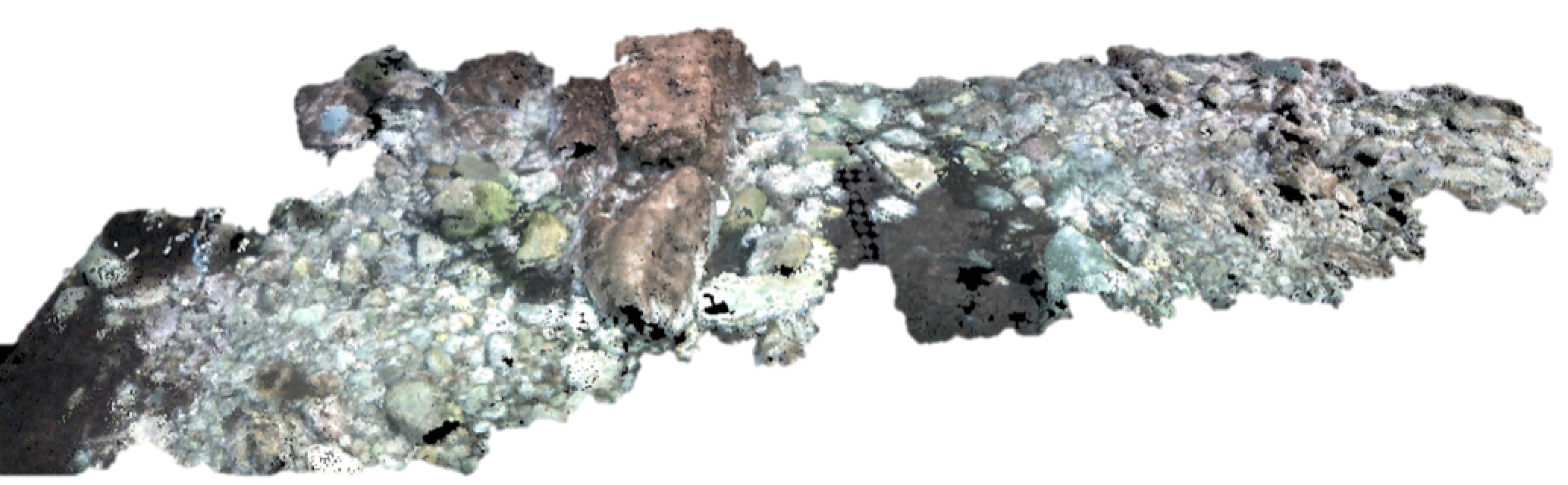
DESCRIPTION
Thanks to recent technological advances, remote and complex underwater scenarios are more accessible for scientific and industrial activities, such as surveying, sampling, rescue or industrial infrastructure inspection and maintenance. Commercial ROVs are endowed with one or several cameras providing an online view of their surroundings to a human operator who is in charge of remotely piloting them.
The reduced field of view and the difficulty to remotely maneuver a 6DOF vehicle with complex dynamics make the ROV piloting a difficult and error prone task requiring trained operators. Our proposal is aimed at solving these problems by providing an advanced, practical and comfortable user interface with three main goals: 1) To build an online, accurate, 3D reconstruction of the robot and all of the explored surroundings, providing an immersive 1st and 3rd person view of the whole explored environment. In subsequent versions, the pilot will be able to select interest areas which will be enlarged and/or revisited if necessary, to be shown with more detail and better resolution. 2) To allow the human operator to command the robot and select goal points in the reconstruction, switching between autonomous and manual control. 3) To fuse online and previously gathered data to establish temporal correlations and observe long-term changes in the sub-sea such as the grow ratio of underwater flora or the degradation of submerged structures. As a result of this work, underwater inspection tasks would significantly change. On the one hand, the remote operation is facilitated, showing in a virtual reality environment the whole explored area, making it less error prone and allowing non trained operators to drive ROVs focusing their effort on decision taking and fine maneuver. On the other hand, the ROV operating range is increased in space, depth and time when compared to tasks currently performed either by ROVs or human divers. Our proposal could be applied to scientific tasks, such as the study of the growth ratio of underwater flora, usually performed by divers who have limited immersion times, increasing the accuracy of the collected data. Also, it could be applied to industrial tasks, such as evaluating the degradation of underwater structures as well as pipe and power and communication cable inspection.
PUBLICATIONS
E. Guerrero, F. Bonin-Font, G. Oliver, Y. González, M. Martín. Sparse Gaussian Process for Online Seagrass Semantic Mapping. In Expert Systems with Applications, Elsevier, vol. 170, pp. 114478, May, 2021 .
.
M. Martín, G. Oliver, Y. González, I. Riutort. A deep learning solution for Posidonia oceanica seafloor habitat multiclass recognition. In IEEE Oceans, Marseilles, 2019.
A. Burguera, F. Bonin-Font. A Trajectory-Based Approach to Multi-Session Underwater Visual SLAM Using Global Image Signatures. In Journal of Marine Science and Engineering, MDPI, vol. 7, no. 8, August, 2019.
F. Bonin-Font. Real-time Hash-based Loop Closure Detection in Underwater Multi-Session Visual SLAM. In IEEE Oceans, Marseille, 2019.
A. Martorell. Design and control of an Autonomous Surface Vehicle to improve Link Communications. 2018
 .
.
A. Burguera. Underwater Localization using Probabilistic Sonar Registration and Pose Graph Optimization. In IEEE OES Autonomous Underwater Vehicle Symposium, Porto (Portugal), 2018.
M. Martín, E. Guerrero, F. Bonin-Font, Y. González. Deep Semantic Segmentation in an AUV for Online Posidonia Oceanica Meadows Identification. In IEEE Access, 2018.
A. Burguera, F. Bonin-Font. Towards Multi Session Visual SLAM in Underwater Environments Colonized with Posidonia Oceanica. In IEEE OES Autonomous Underwater Vehicle Symposium, Porto, 2018.
F. Bonin-Font, J. Lalucat, G. Oliver, M. Massot, E. Guerrero, P. L. Negre. Evaluating the Impact of Sewage Discharges on the Marine Environment with a Lightweight AUV. In Marine Pollution Bulletin, Elsevier, vol. 135, pp. 714-722, October, 2018.
F. Bonin-Font, M. Massot, A. Burguera. ARSEA: A Virtual Reality Subsea Exploration Assistant. In 11th IFAC Conference on Control Applications in Marine Systems, Robotics, and Vehicles, 2018.
N. Muntaner, A. Jimenez, F. Bonin-Font. Reconstrucción Visual 3D para el prediagnóstico de heridas post-operatorias. In XV Reunión de Salut Conectada, Hospital Clínico Universitario Lozano Blesa, Zaragoza, 2017.
N. Muntaner, F. Bonin-Font, J. J. Segura, A. Jimenez, P. L. Negre, M. Massot, F. X. Gonzalez, G. Oliver. Towards a Pre-diagnose of Surgical Wounds Through the Analysis of Visual 3D Reconstructions.. In International Conference on Computer Vision Theory and Applications (VISSAP), 2018.
F. Bonin-Font, A. Burguera, J. Luís. Visual Discrimination and Large Area Mapping of Posidonia Oceanica Using a Lightweight AUV. In IEEE Access, IEEE, vol. 5, no. 1, pp. 24479-24494, 2017.
F. Bonin-Font, G. Oliver. Hacia la Navegación Visual de un Vehı́culo Autónomo Submarino en Areas con Posidonia Oceanica. In Revista Iberoamericana de Automática e Informática Industrial, Elsevier, vol. 15, no. 1, 2017.
J. Guerrero, J. J. Miñana, O. Valero, G. Oliver. Indistinguishability Operators Applied to Task Allocation Problems in Multi-Agent Systems. In Applied Sciences, MDPI, vol. 7, no. 10, pp. 1-16, September, 2017.
A. Burguera. A Novel Approach to Register Sonar Data for Underwater Robot Localization. In IEEE IntelliSys, London, UK, 2017.
A. Burguera, F. Bonin-Font, E. García. Building Large-Scale Coverage Maps of Posidonia Oceanica using an Autonomous Underwater Vehicle. In MTS/IEEE Oceans, Aberdeen, Scotland, 2017.
F. Bonin-Font, M. Massot, P. L. Negre, G. Oliver, E. Guerrero, E. García. Towards a new Methodology to Evaluate the Environmental Impact of a Marine Outfall Using a Lightweight AUV. In MTS/IEEE Oceans , Aberdeen, 2017.
E. Guerrero, F. Bonin-Font, P. L. Negre, M. Massot, G. Oliver. USBL Integration and Assessment in a Multisensor Navigation Approach for AUVs. In The 20th World Congress of the International Federation of Automatic Control (IFAC World Congress), Toulouse, 2017.
Y. González, A. Burguera, F. Bonin-Font, A. Matamoros. Machine Learning and Deep Learning Strategies to Identify Posidonia Meadows in Underwater Images. In MTS/IEEE OCEANS17 Aberdeen , Aberdeen, Scotland, 2017.
M. Massot, F. Bonin-Font, P. L. Negre, E. Guerrero, A. Martorell, G. Oliver. A 3D Mapping, Obstacle Avoidance and Acoustic Communication Payload for the AUV SPARUS II. In 7th International Workshop on Marine Technology (MARTECH), Barcelona, Spain, 2016.
E. Guerrero, M. Massot, P. L. Negre, F. Bonin-Font, G. Oliver. An USBL-Aided Multisensor Navigation System for Field AUVs. In IEEE International Conference on Multisensor Fusion and Integration for Intelligent Systems (MFI ) , Baden-Baden, pp. 430-435, 2016.
A. Burguera, F. Bonin-Font, J. Luís, A. Belén. Towards Automatic Visual Sea Grass Detection in Underwater Areas of Ecological Interest. In IEEE International Conference on Emerging Technologies and Factory Automation, Berlin, 2016.
F. Bonin-Font, M. Massot, G. Oliver. Towards Visual Detection, Mapping and Quantification of Posidonia Oceanica using a Lightweight AUV. In IFAC International Conference on Control Applications in Marine Systems, Trondheim, pp. 500-505, 2016.
A. Burguera, G. Oliver. High-Resolution Underwater Mapping Using Side-Scan Sonar. In PLOS ONE, vol. 11, no. 1, pp. 1-41, January, 2016.
P. L. Negre, F. Bonin-Font, G. Oliver. Cluster-Based Loop Closing Detection for Underwater SLAM in Feature-Poor Regions. In IEEE International Conference on Robotics and Automation (ICRA), Stockholm (Sweeden), 2016.
A. Burguera, G. Oliver. Building High Resolution Maps of Large Subsea Areas Using Side-scan Sonar. In Actas de las XXXVI Jornadas de Automática, Bilbao, pp. 842 - 849, 2015.
P. L. Negre, F. Bonin-Font, G. Oliver. Global Image Signature for Visual Loop-Closure Detection. In Autonomous Robots, Springer, vol. 40, pp. 1403-1417, December, 2016.
F. Bonin-Font, , M. Massot, G. Oliver. Visual Characterization and Automatic Detection of Posidonia Oceanica for Meadows Mapping using an AUV. In INTERNATIONAL WORKSHOP ON MARINE TECHNOLOGY, Cartagena, 2015.
P. L. Negre, F. Bonin-Font, G. Oliver. [Report] Hash-based Loop-Closure Detection. 2015.
.M. Martín, G. Oliver, Y. González, I. Riutort. A deep learning solution for Posidonia oceanica seafloor habitat multiclass recognition. In IEEE Oceans, Marseilles, 2019.
A. Burguera, F. Bonin-Font. A Trajectory-Based Approach to Multi-Session Underwater Visual SLAM Using Global Image Signatures. In Journal of Marine Science and Engineering, MDPI, vol. 7, no. 8, August, 2019
.F. Bonin-Font. Real-time Hash-based Loop Closure Detection in Underwater Multi-Session Visual SLAM. In IEEE Oceans, Marseille, 2019.
A. Martorell. Design and control of an Autonomous Surface Vehicle to improve Link Communications. 2018
.A. Burguera. Underwater Localization using Probabilistic Sonar Registration and Pose Graph Optimization. In IEEE OES Autonomous Underwater Vehicle Symposium, Porto (Portugal), 2018.
M. Martín, E. Guerrero, F. Bonin-Font, Y. González. Deep Semantic Segmentation in an AUV for Online Posidonia Oceanica Meadows Identification. In IEEE Access, 2018
.A. Burguera, F. Bonin-Font. Towards Multi Session Visual SLAM in Underwater Environments Colonized with Posidonia Oceanica. In IEEE OES Autonomous Underwater Vehicle Symposium, Porto, 2018.
F. Bonin-Font, J. Lalucat, G. Oliver, M. Massot, E. Guerrero, P. L. Negre. Evaluating the Impact of Sewage Discharges on the Marine Environment with a Lightweight AUV. In Marine Pollution Bulletin, Elsevier, vol. 135, pp. 714-722, October, 2018
.F. Bonin-Font, M. Massot, A. Burguera. ARSEA: A Virtual Reality Subsea Exploration Assistant. In 11th IFAC Conference on Control Applications in Marine Systems, Robotics, and Vehicles, 2018.
N. Muntaner, A. Jimenez, F. Bonin-Font. Reconstrucción Visual 3D para el prediagnóstico de heridas post-operatorias. In XV Reunión de Salut Conectada, Hospital Clínico Universitario Lozano Blesa, Zaragoza, 2017.
N. Muntaner, F. Bonin-Font, J. J. Segura, A. Jimenez, P. L. Negre, M. Massot, F. X. Gonzalez, G. Oliver. Towards a Pre-diagnose of Surgical Wounds Through the Analysis of Visual 3D Reconstructions.. In International Conference on Computer Vision Theory and Applications (VISSAP), 2018.
F. Bonin-Font, A. Burguera, J. Luís. Visual Discrimination and Large Area Mapping of Posidonia Oceanica Using a Lightweight AUV. In IEEE Access, IEEE, vol. 5, no. 1, pp. 24479-24494, 2017
.F. Bonin-Font, G. Oliver. Hacia la Navegación Visual de un Vehı́culo Autónomo Submarino en Areas con Posidonia Oceanica. In Revista Iberoamericana de Automática e Informática Industrial, Elsevier, vol. 15, no. 1, 2017
.J. Guerrero, J. J. Miñana, O. Valero, G. Oliver. Indistinguishability Operators Applied to Task Allocation Problems in Multi-Agent Systems. In Applied Sciences, MDPI, vol. 7, no. 10, pp. 1-16, September, 2017
.A. Burguera. A Novel Approach to Register Sonar Data for Underwater Robot Localization. In IEEE IntelliSys, London, UK, 2017.
A. Burguera, F. Bonin-Font, E. García. Building Large-Scale Coverage Maps of Posidonia Oceanica using an Autonomous Underwater Vehicle. In MTS/IEEE Oceans, Aberdeen, Scotland, 2017.
F. Bonin-Font, M. Massot, P. L. Negre, G. Oliver, E. Guerrero, E. García. Towards a new Methodology to Evaluate the Environmental Impact of a Marine Outfall Using a Lightweight AUV. In MTS/IEEE Oceans , Aberdeen, 2017.
E. Guerrero, F. Bonin-Font, P. L. Negre, M. Massot, G. Oliver. USBL Integration and Assessment in a Multisensor Navigation Approach for AUVs. In The 20th World Congress of the International Federation of Automatic Control (IFAC World Congress), Toulouse, 2017.
Y. González, A. Burguera, F. Bonin-Font, A. Matamoros. Machine Learning and Deep Learning Strategies to Identify Posidonia Meadows in Underwater Images. In MTS/IEEE OCEANS17 Aberdeen , Aberdeen, Scotland, 2017.
M. Massot, F. Bonin-Font, P. L. Negre, E. Guerrero, A. Martorell, G. Oliver. A 3D Mapping, Obstacle Avoidance and Acoustic Communication Payload for the AUV SPARUS II. In 7th International Workshop on Marine Technology (MARTECH), Barcelona, Spain, 2016
.E. Guerrero, M. Massot, P. L. Negre, F. Bonin-Font, G. Oliver. An USBL-Aided Multisensor Navigation System for Field AUVs. In IEEE International Conference on Multisensor Fusion and Integration for Intelligent Systems (MFI ) , Baden-Baden, pp. 430-435, 2016
.A. Burguera, F. Bonin-Font, J. Luís, A. Belén. Towards Automatic Visual Sea Grass Detection in Underwater Areas of Ecological Interest. In IEEE International Conference on Emerging Technologies and Factory Automation, Berlin, 2016.
F. Bonin-Font, M. Massot, G. Oliver. Towards Visual Detection, Mapping and Quantification of Posidonia Oceanica using a Lightweight AUV. In IFAC International Conference on Control Applications in Marine Systems, Trondheim, pp. 500-505, 2016
.A. Burguera, G. Oliver. High-Resolution Underwater Mapping Using Side-Scan Sonar. In PLOS ONE, vol. 11, no. 1, pp. 1-41, January, 2016
.P. L. Negre, F. Bonin-Font, G. Oliver. Cluster-Based Loop Closing Detection for Underwater SLAM in Feature-Poor Regions. In IEEE International Conference on Robotics and Automation (ICRA), Stockholm (Sweeden), 2016
.A. Burguera, G. Oliver. Building High Resolution Maps of Large Subsea Areas Using Side-scan Sonar. In Actas de las XXXVI Jornadas de Automática, Bilbao, pp. 842 - 849, 2015.
P. L. Negre, F. Bonin-Font, G. Oliver. Global Image Signature for Visual Loop-Closure Detection. In Autonomous Robots, Springer, vol. 40, pp. 1403-1417, December, 2016
.F. Bonin-Font, , M. Massot, G. Oliver. Visual Characterization and Automatic Detection of Posidonia Oceanica for Meadows Mapping using an AUV. In INTERNATIONAL WORKSHOP ON MARINE TECHNOLOGY, Cartagena, 2015.
P. L. Negre, F. Bonin-Font, G. Oliver. [Report] Hash-based Loop-Closure Detection. 2015
.